A future
to the north
Canada’s Energy Corridor: Built to unify, designed to export.
The Northern Spine Energy Corridor
Overview:
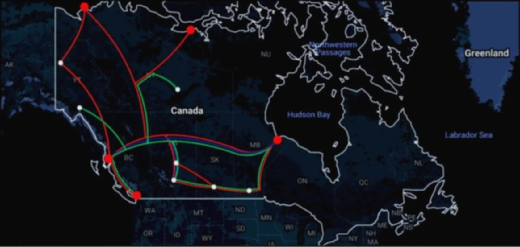
The Northern Spine is a unified, multi-use infrastructure corridor that stretches from Prince Rupert, British Columbia to Port Nelson, Manitoba. It combines pipeline, heavy freight rail, and electrification/data lines into a single strategic route designed to unlock Canada’s northern and interior potential. It forms the physical foundation of Phase 1 of the Canadian Catalyst Initiative.
From west to east

The Northern Spine is a national energy corridor connecting Prince Rupert, BC to Port Nelson, MB—combining pipeline, heavy freight rail, and electrification into a unified route built to move resources, power, and goods across Canada’s northern frontier.
Core Infrastructure Components
🔵 Pipeline (Blue)
Transports oil, gas, and potentially hydrogen in the future
Gives Western provinces a secure, eastbound export route
Bypasses opposition-heavy regions (Vancouver, Toronto, Quebec) while minimizing environmental impact by following a centralized footprint
🔴 Heavy Freight Rail (Red)
Moves bulk commodities: grain, minerals, metals, energy products
Enables modular submarine transport from Vancouver to Arctic ports
Connects industrial centers like Calgary, Edmonton, and Winnipeg to national and global supply chains
🟢 Energy & Communications Corridor (Green)
HVDC power lines and fiber-optic backbone
Supports future AI infrastructure, data centers, research nodes, and Arctic sovereignty
Connects Canada's digital future to physical infrastructure
“Aligning the Future With the Foundations We Already Have”


Geostrategic Importance
Western Terminus: Prince Rupert & Vancouver
Prince Rupert offers direct access to global shipping lanes via one of North America’s deepest natural harbours
Acts as the primary export outlet for Canadian energy, critical minerals, and heavy freight, particularly from Western and Northern provinces
Integrates with existing CN rail and Pacific trade infrastructure, minimizing new buildout costs
Vancouver region supports industrial capacity—serving as a manufacturing and logistics hub for pipeline components, rail equipment, and marine infrastructure
Supports defensive and logistical staging for submersibles, enhancing coastal and Arctic sovereignty
Eastern Terminus: Port Nelson, MB
Offers direct Arctic access, uniquely positioned along the emerging Northwest Passage trade route
Poised to become Canada’s premier northern export port, bridging domestic supply chains with European and Asian markets
Connects directly to Manitoba Hydro and prairie rail grids—serving as an energy transmission and export node
Creates opportunity for resource aggregation from Alberta oil, Saskatchewan grain, Manitoba minerals, and beyond
Dual use: Serves as the deployment point for Arctic submersibles and a future site for repair/refit infrastructure, resupply stations, and naval logistics

Region
Role
Port/export node, marine shipping hub
Prince Rupert
Manufacturing base, training, R&D for submersibles
Vancouver
Oil/gas source, logistics/maintenance hubs
Calgary & Edmonton
Midpoint control centers, intermodal transfer zones
Regina & Winnipeg
Final assembly, launch platform, Arctic trade and sovereignty gate
Port Nelson
Northern Extensions
Richards Island
High-potential site for Arctic submarine deployment and scientific research
Grays Bay (NU)
Example of industrial-Arctic hybrid use; potential site for mineral exports and joint Arctic research
Yellowknife, Whitehorse, Dawson City
Candidate locations for regional support centers, data relay nodes, and long-term rail connectivity
Functional Philosophy
The Northern Spine is not just a pipeline. It is the backbone of a connected nation, the lifeline of Arctic sovereignty, and the railway of Canadian economic independence. It is a unified conduit—moving energy, goods, intelligence, and national will across our northern frontier.
Designed with both national and global strategy in mind, it opens a direct corridor to Asian and European markets, reduces our dependence on U.S. supply chains, and strengthens our position in defense, trade, and digital autonomy.
It’s not just infrastructure—it’s Canadian resilience, by design.


We need your help!
The Northern Spine is the physical foundation of a sovereign, connected, 21st-century Canada. It is where energy, economy, and national identity converge—and where the nation begins to build again.
…and where the nation begins to build again. Explore how you can contribute to shaping Canada’s next great chapter.